 Hoy domingo
hemos hecho una excursión para conocer
Hoy domingo
hemos hecho una excursión para conocer
Le tocó el
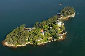
turno a la Isla de San Simón. La isla
preside la ensenada de San Simón, en el extremo interior de la ría de Vigo, que
baña los municipios de Redondela, Sotomayor y Vilaboa. Está unida a la isla de
San Antón por un puente. El conjunto de las dos islas mide 250 metros de ancho
y 84 de largo. Además existen otros dos pequeños islotes, San Bartolomé y San
Norberto. A lo largo de su historia la isla fue empleada como monasterio,
lazareto, cárcel y hogar para niños huérfanos.
El conjunto de
las dos islas está catalogado como Bien de Interés Cultural con categoría de
sitio histórico desde 1999. Entre los siglos XII y XIII estuvo habitada por los
templarios y después por los franciscanos, la orden de los pascualinos de San
Simón. Pero en 1370 esta orden religiosa sufre la excomulgación, viéndose
obligada a abandonar la isla. En 1589 fue saqueada por piratas ingleses, entre
los que se encuentra el célebre Francis Drake.
 Pero también
tuvo su función como cárcel y lugar de exterminio en la Guerra civil española
donde más de 6000 prisioneros pasaron por allí. Sus historias son
interminables, muerte, hambre, desolación… pero también un lugar bonito donde
pasear. Este lugar está compuesto por dos islas y en ambas hay diferentes
edificios que durante todas sus etapas
se utilizaron para diferentes fines.
Pero también
tuvo su función como cárcel y lugar de exterminio en la Guerra civil española
donde más de 6000 prisioneros pasaron por allí. Sus historias son
interminables, muerte, hambre, desolación… pero también un lugar bonito donde
pasear. Este lugar está compuesto por dos islas y en ambas hay diferentes
edificios que durante todas sus etapas
se utilizaron para diferentes fines.
Entre otras,
el paseo de los “buxos” que es el más antiguo de Europa con 200 años. Pero sus
vistas, flora y esculturas hacen del lugar algo muy especial que recomiendo
visitar, sobre todo con guía para que nos explique la historia.
La ensenada
fue escenario de la batalla de Rande en 1702, cuando los navíos de Holanda y de
Inglaterra, unidos por la Guerra de Sucesión contra la corona de Castilla,
trataron de asaltar la flota de Indias cargada con las mercancías de casi 3
años.
A partir de
1936, con la llegada de la Guerra Civil Española los edificios de la isla
fueron empleados como campo de concentración y de exterminio para los presos
políticos contrarios al Franquismo, en un primer momento su mayoría provenían
de zonas próximas como Vigo, Pontevedra, Orense y Villagarcía de Arosa. Después
de la caída del frente norte republicano los presos provenían de Asturias,
León, Cantabria y País Vasco, terminada la guerra civil fueron trasladados
presos desde todas las cárceles de España. (fuentes: Wikipedia)
En el año 1999
las islas de San Simón y de San Antón fueron declaradas Bien de interés
cultural y comenzó la reconstrucción.
 De aquí nos
dirigimos al “Banco de Redondela”,
famoso banco gallego desde donde las vistas son impresionantes y donde nuestro
léxico no sería suficiente para poder describir tanta belleza y paz.
De aquí nos
dirigimos al “Banco de Redondela”,
famoso banco gallego desde donde las vistas son impresionantes y donde nuestro
léxico no sería suficiente para poder describir tanta belleza y paz.
A este lo
denominan el banco más bonito del mundo y si lo visitáis, sabréis el porqué, yo
no voy a desvelar nada. Pero si debo decir que hay dos bancos que se disputan
dicho “puesto”: El primero ubicado en los acantilados de Loiba, y el segundo en
Redondela, sobre la ría de Vigo.
El
banco ubicado en Redondela tiene un origen misterioso. Nadie sabe quién lo
coloco, pero se sabe que fue en el año 2015. Su espectacular vista abarca toda
la ría de Vigo. Este banco tiene tallado
a su espalda “Galiza. It’s different”, frase que de simple no tiene nada, ya
que atrae a la gente a Galicia simplemente a experimentar la vista que ofrece
este banco.
Una vez visto
este espectáculo comimos para reponer fuerzas y nos dirigimos al siguiente
punto de visita, las salinas de Ulló.
En Vilaboa existen los restos de unas salinas del siglo XVII que han sido
restauradas en la primera década del siglo XXI. La zona del pequeño valle donde
se encuentra el conjunto intermareal y etnográfico se denominaba Ulló y por ello se denominan Salinas de Ulló
actualmente, aunque se ubique en el barrio de Paredes.
El Rego Tuimil
y el Villil desembocan en una bahía de la Ensenada de San Simón formando unas
hermosas marismas de agua salada de bajo nivel. Cuando sube la marea la tierras
bajas se inundan pasando a formar parte de la ría. Por eso fue, que en 1637 se
aprovechara la bahía para crear unas grandes salinas. Se construyeron casi 1 km
de dique para contener las aguas saladas. Estas salinas comenzaron a ser explotadas por
el Colegio de los Jesuitas de Pontevedra en 1694 y su uso se remontó
prácticamente hasta el siglo XX. (fuente:galiciamaxica.ue)

Después de esta maravilla visitamos el Puente de Sampaio. Toma su nombre del
puente que la une a la antigua provincia de Tuy por la parroquia de Arcade y
donde fue librada una batalla, la conocida como Batalla de Pontesampaio,
decisiva en la Guerra de la Independencia Española contra los franceses el 7 y
8 de junio de 1809, que puso fin a cinco meses de ocupación francesa.
También es
conocida por laMuiñeira de Pontesampaio, que se supone que fue tocada durante la batalla
que tuvo lugar a las orillas del río Verdugo.
Nuestra excursión
casi llegaba a su fin aunque nos quedaba
todavía el Monte da Peneda. Cerca de la desembocadura del Río Verdugo,
donde comienza la Ría de Vigo, se
levanta un montículo solitario de forma piramidal que se eleva a 329 m. Su alto
es lugar de grandes panorámicas entre ellas se divisa la entrada de la Ría de Vigo y buena
parte de sus riberas, con las Islas Cíes al fondo. El lugar fue desde tiempos
lejanos ocupado por diversos emplazamientos, entre los que destacan un antiguo
castro y el Castillo de Castrizán. Este fue construído en 1477 por el Arzobispo
de Santiago Alonso de Fonseca para vigilar a Pedro Madruga que poseía el
castillo de Soutomaior y que no era partidario de los reyes católicos y apoyaba
a Urraca y a los portugueses. Es un lugar interesante que al estar cerca de
todo lo que hemos visto hasta ahora, merece la pena visitar y de paso, hacemos
ejercicio sano con vistas increíbles.
Pues bien,
hasta aquí todo lo que vimos este domingo. Seguramente habrá más y os haré
participes de las maravillas que guarda esta región.
Montserrat A
Island of San Simón, salinas of Ulló, P. Sampaio
and Monte da Peneda
Today on
Sunday we have made an excursion to know one of the most
beautiful parts of Galicia that are not few.
It was the turn
of the Island of San Simón. The island presides over the cove of San Simón, at
the inner end of the Vigo estuary, which bathes the municipalities of
Redondela, Sotomayor and Vilaboa. It is linked to the island of San Antón by a
bridge. The set of the two islands is 250 meters wide and 84 meters long. There
are also two other small islets, San Bartolomé and San Norberto. Throughout its
history the island was used as a monastery, lazaretto, prison and home for
orphaned children.
 |
| los buxos |
The group of
the two islands is classified as an Asset of Cultural Interest with a
historical site category since 1999. Between the 12th and 13th centuries it was
inhabited by the Templars and later by the Franciscans, the Order of the
Pascualinos of San Simón. But in 1370 this religious order suffers the
excommunication, being forced to leave the island. In 1589 it was sacked by
English pirates, among whom is the famous Francis Drake.
But it also
had its function as a prison and place of extermination in the Spanish Civil
War where more than 6000 prisoners passed through there. Their stories are
endless, death, hunger, desolation ... but also a nice place to walk. This
place is made up of two islands and in both there are different buildings that
during all their stages were used for different purposes.
Among others,
the walk of the "buxos" which is the oldest in Europe with 200 years.
But its views, flora and sculptures make the place something very special that
I recommend visiting, especially with a guide to explain the history.
The cove was
the scene of the Battle of Rande in 1702, when the ships of Holland and
England, united by the War of Succession against the Crown of Castile, tried to
assault the Indian fleet loaded with goods of almost 3 years.
From 1936,
with the arrival of the Spanish Civil War, the buildings of the island were
used as a concentration and extermination camp for political prisoners opposed
to the Franco regime, at first most of them came from nearby areas such as
Vigo, Pontevedra, Orense and Villagarcía de Arosa. After the fall of the
republican north front, the prisoners came from Asturias, León, Cantabria and
the Basque Country. After the civil war ended, prisoners were transferred from
all prisons in Spain. (sources: Wikipedia)
In 1999, the
islands of San Simón and San Antón were declared of cultural interest and
reconstruction began.
From here we
went to the "Bank of Redondela", famous Galician bank from where the
views are impressive and where our lexicon would not be enough to describe so
much beauty and peace.
This is called
the most beautiful bank in the world and if you visit, you will know why, I
will not reveal anything. But I must say that there are two banks that dispute
said "position": The first located on the cliffs of Loiba, and the
second in Redondela, on the Vigo estuary.
 |
| Vistas puente de Rande desde la Isla San Simón |
The bank located in Redondela has a mysterious origin. Nobody knows who put it,
but it is known that it was in 2015. Its spectacular view covers the entire
Vigo estuary. This bank has carved on his back "Galiza. It's different
", a phrase that simply does not have anything, since it attracts people
to Galicia simply to experience the view that this bank offers.
Once we saw
this show we ate to recover our strength and we headed to the next point of
visit, the Salinas de Ulló.
In Vilaboa there are the remains of seventeenth century salinas that
have been restored in the first decade of the 21st century. The area of the
small valley where the intertidal and ethnographic group is located was called
Ulló and for this reason they are currently called Salinas de Ulló, although it
is located in the Paredes neighborhood.
The Reim
Tuimil and the Villil flow into a bay of the San Simón Cove, forming beautiful
salt marshes of low level. When the tide rises the lowlands are flooded
becoming part of the estuary. That's why, in 1637, the bay was used to create
large salt works. Almost 1 km of dike were built to contain the salty waters.
These salinas began to be exploited by the Jesuit College of Pontevedra in 1694
and its use went back almost to the 20th century. (source: galiciamaxica.ue)
After this wonder we visited the Sampaio Bridge. It takes its name from the
bridge that links it to the old province of Tuy by the parish of Arcade and
where a battle was fought, known as the Battle of Pontesampaio, decisive in the
War of Spanish Independence against the French on June 7 and 8 of 1809, which
ended five months of French occupation.
It is also
known for the Muiñeira de Pontesampaio, that is supposed
to have been played during the battle that took place on the banks of the
Verdugo River.
 |
| Puente que une la dos islas. |
Our tour
almost came to an end although we still had Monte da Peneda. Near the mouth of
the Verdugo River, where the Ría de Vigo begins, a solitary mound of pyramidal
form rises to 329 m. Its height is the place of great panoramic views,
including the entrance of the Ría de Vigo and a good part of its banks, with
the Cíes Islands in the background. The place was from distant times occupied
by diverse emplacements, between which they emphasize an old castro and the
Castle of Castrizán. This was built in 1477 by the Archbishop of Santiago
Alonso de Fonseca to watch Pedro Madruga who owned the castle of Soutomaior and
who was not a supporter of the Catholic kings and supported Urraca and the
Portuguese. It is an interesting place that being close to everything we have
seen so far, it is worth visiting and, in passing, we do healthy exercise with
incredible views.
Well, so far
everything we saw this Sunday. Surely there will be more and I will share with
you the wonders that this region has.
Montserrat A
No hay comentarios:
Publicar un comentario